





A practical Korea-map routine starts with one dependable place record. Use NAVER Map to understand the stop you have in mind, then use KakaoMap to choose the next move that gets you there.
You have saved a restaurant, a gallery, or the lobby of your hotel. The name looks clear enough in English, but a taxi driver, a reservation page, a station sign, and a map search may each present the same stop differently. The useful item to carry is the place written in Korean, with an address and one nearby landmark.
That small record gives a Korea trip some continuity. The Korea Tourism Organization’s transport guide places NAVER Map and KakaoMap in the same visitor toolkit for driving, public-transit, and walking searches. The two apps become especially useful when you give each one a clear job.
Start with a place record
Before you leave your accommodation, make a note that can travel across apps and conversations. Keep the official English name, Korean name, street address, nearest station or landmark, and the official booking, ticket, or contact link together.
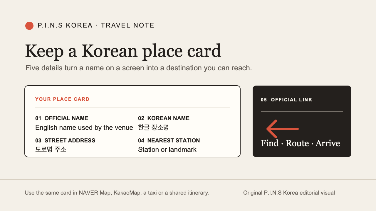
Korean place card. Original P.I.N.S Korea editorial visual.
This is a practical reference for the moment when you are standing outside a station, a reservation message has arrived in Korean, or a friend sends a pin from another phone.
NAVER Map helps you make the first decision
When you are still deciding whether a place belongs in the day, open NAVER Map. NAVER’s multilingual visitor guide describes support in Korean, English, Chinese, and Japanese, alongside place exploration, public-transit arrival information, subway maps, boarding guidance, and exit information. Its multilingual place update also covers translated Korean text reviews and restaurant filters.
Read the Korean name and address alongside the translated information. Look at opening hours, photos, and reviews. If the destination is a restaurant, filters can help you compare several options before you commit to a long cross-city ride. If it is a museum, concert venue, or neighbourhood address, the nearest station and exit information give the plan a physical shape.
The point is simple: decide whether this is the right place before you decide how to travel there.
KakaoMap helps you choose the next move
Once the stop is fixed, KakaoMap becomes a strong route screen. Its official service page presents public-transit, car, walking, and bicycle routes, together with in-app navigation.
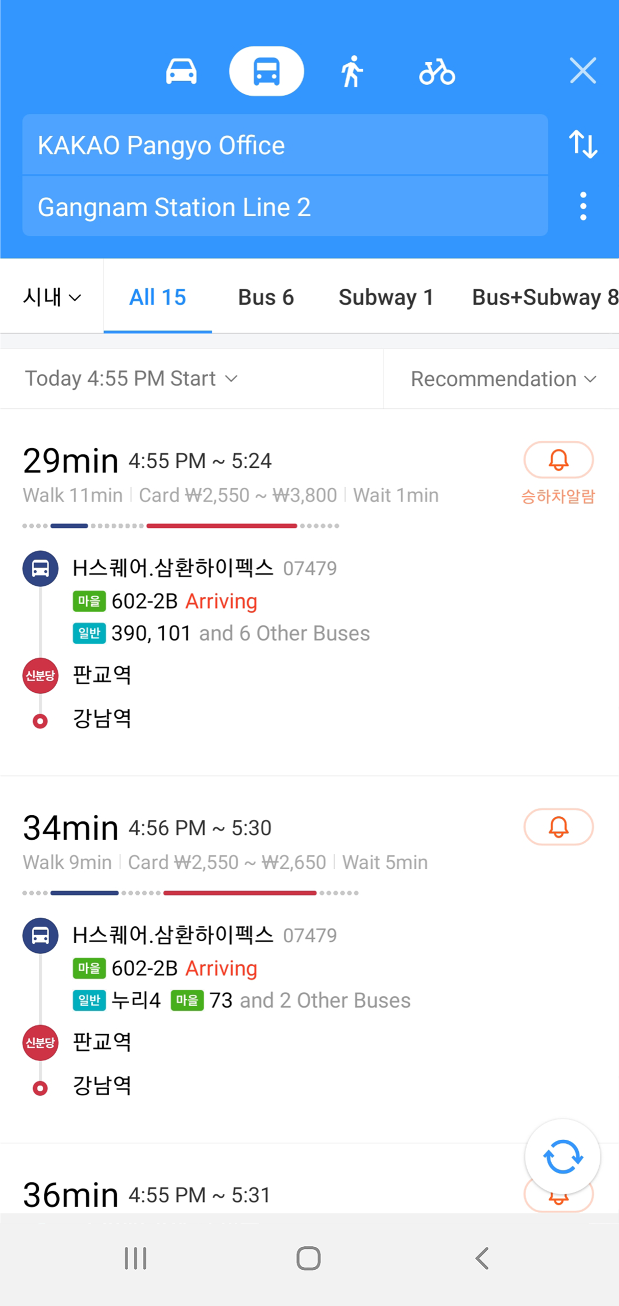
KakaoMap public-transit route and boarding/alighting alert. Source: KakaoMap service page.
Enter the Korean name or street address from the place record. Then read the route as a plan, not a single number. A route with one fewer transfer can be the better choice when you have luggage. A short walk may be welcome before dinner and less appealing in heavy rain. KakaoMap’s service page also describes boarding and alighting notifications for public transport.
At the station, simplify the transfer
Large Korean stations can turn a good route into a hurried one. Keep the place record open, follow the current route screen, and use the information that makes the next decision easier: the platform, the transfer point, the destination direction, and the exit closest to the stop.
NAVER’s visitor guide highlights real-time public-transit arrival information, subway maps, boarding guidance, and exit information. Kakao’s June 2025 subway announcement introduced a train-position view for supported lines, including Airport Railroad and GTX-A at launch. Reopen the live route before the transfer rather than relying on an itinerary screenshot saved that morning.
A two-app routine for a real day in Korea
| Moment | Your question | Useful starting point |
|---|---|---|
| Choosing a café, restaurant, attraction, or venue | Is this the right stop? | NAVER Map: Korean name, address, hours, photos, reviews, and place details |
| Adding it to the day | What information should travel with me? | Save the Korean name, address, landmark, and official link in one place record |
| Leaving a hotel, station, or previous stop | Which route suits this moment? | KakaoMap: transit, walking, car, or bicycle options |
| Riding and transferring | What should I follow now? | The current route screen, arrival guidance, and any available alerts |
| Reaching the destination | Which exit or entrance brings me closest? | NAVER Map place and transit details, plus the venue’s official instructions |
NAVER Map helps you read a place before the day starts. KakaoMap helps you turn that place into a route when it is time to move. Carrying both makes the journey feel less like a series of isolated searches and more like one connected plan.
Official starting links
- Korea Tourism Organization: visitor transport and route tools
- NAVER: multilingual guide for foreign visitors
- NAVER: multilingual place reviews and filters
- KakaoMap: official service features
- KakaoMap: June 2025 live subway update
Feature descriptions were checked on August 21, 2026. Use the current app screen for live route and service information on the day you travel.